Leveling observations and data modeling
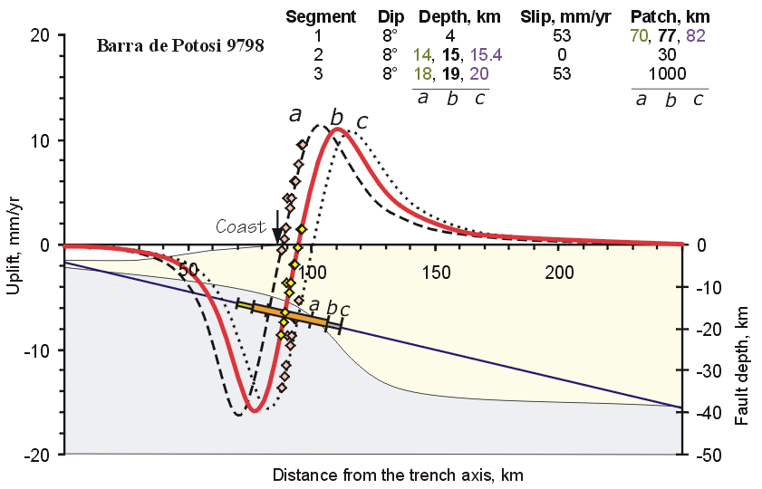
Fig. 1a. Modeling of the vertical uplift rate for the Barra de Potosí leveling line (Elastic dislocation model, Savage, 1983). Shaded areas below the zero fault depth line represent the configuration of the subducting Cocos plate and the interplate contact according to Kostoglodov et al., (1996). The geometric parameters of the fault segments and the slip rate are given in the tables at the top of the Figure. Locked segments are shown as elongated filled rectangles. a - Planar fault model. Different models (a, b, c) can fit the observed relative uplift rate, nevertheless, the location and width of the locked zone hardly show any variations.
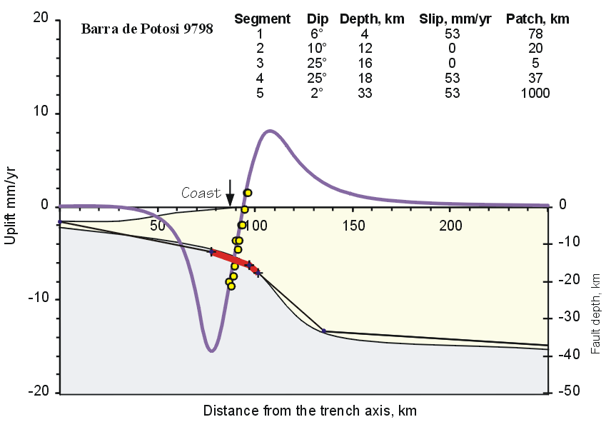
Fig. 1b - Better fit to the uplift and the interplate geometry using a segmented fault model. The location of the locked zone is approximately the same as in case a. Locked segments are shown as red heavy solid lines. Other explanations are the same as for Figure 1.
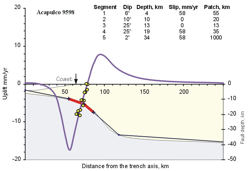
Fig. 2. Comparison of the predicted vertical motion and the observed vertical uplift rate (1995-1998 epoch) for the Acapulco leveling line. Segmented fault fitting the interplate geometry. Locked segments are shown as red heavy solid lines. Other explanations are the same as for Figure 1.
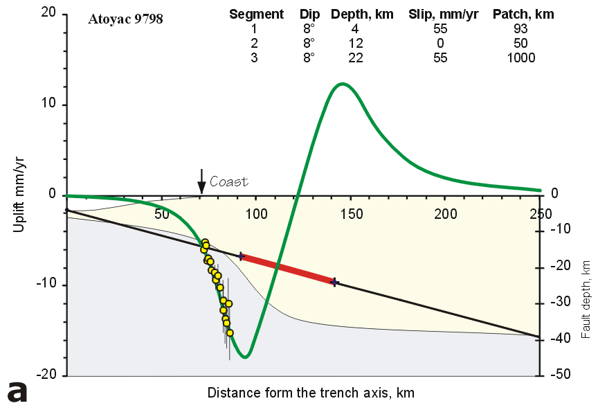
Fig. 3a. Predicted vertical motion on the Atoyac line. Interseismic coupling model (a) - simple plane fault for the subsiding coastal area. The data can only be fitted if the locked segment location does not agree with the interplate contact configuration. Locked segments are shown as red heavy solid lines. Vertical bars are one sigma cumulative standard deviations of the relative uplift rate estimates. For other explanations see Figure 1.
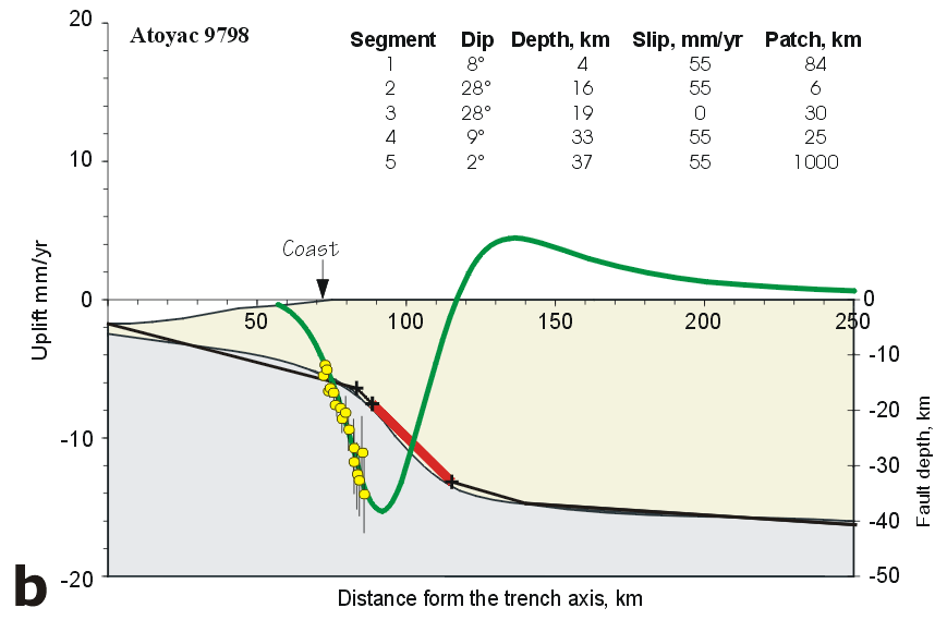
Fig. 3b. Predicted vertical motion on the Atoyac line. Interseismic coupling model (b) - complex plane fault for the subsiding coastal area. The locked seismogenic zone is too deep and rather far from the coast. Locked segments are shown as red heavy solid lines. Vertical bars are one sigma cumulative standard deviations of the relative uplift rate estimates. For other explanations see Figure 1.
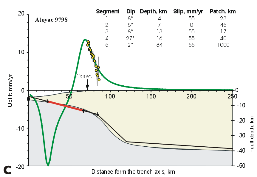
Fig. 3c. Predicted vertical motion on the Atoyac line. Interseismic coupling model (c) - complex plane fault for the uplifting coastal area. Geometry of the locked zone is reasonable. Locked segments are shown as red heavy solid lines. Vertical bars are one sigma cumulative standard deviations of the relative uplift rate estimates. For other explanations see Figure 1. For other explanations see Figure 1.
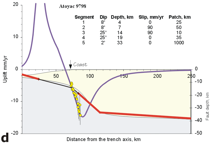
Fig. 3d. Predicted vertical motion on the Atoyac line. Coseismic slip or "Slow rupture" model (d) reveals the slipping faults, which are consistent with the interplate geometry. The model fits the data for the subsiding coast. Locked segments are shown as red heavy solid lines. Vertical bars are one sigma cumulative standard deviations of the relative uplift rate estimates. For other explanations see Figure 1.
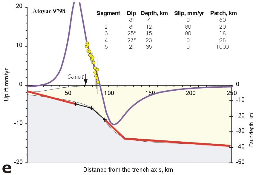
Fig. 3e. Predicted vertical motion on the Atoyac line. Coseismic slip or "Slow rupture" model (e) reveals the slipping faults, which are consistent with the interplate geometry. The model fits well the coastal uplift. Locked segments are shown as red heavy solid lines. Vertical bars are one sigma cumulative standard deviations of the relative uplift rate estimates. For other explanations see Figure 1.
In order to unequivocally determine the deformation mode attendant to the interseismic regime in the Guerrero gap, we will combine the differential leveling data with GPS survey data to be gathered in late 2000.