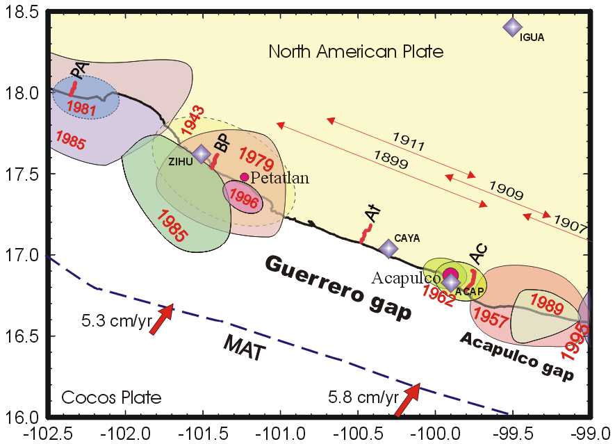
Fig. 1. Location of leveling lines on the Pacific coast of Guerrero. Leveling lines are: PA - Playa Azul, BP - Barra de Potosí, At - Atoyac, Ac - Acapulco. Shaded areas annotated with a year are rupture zones of recent large thrust earthquakes. Thin arrows located inland, over the Guerrero gap indicate an approximate extent along the coastal area of the rupture of the large earthquakes in 1899, 1907, 1909, and 1911. Solid arrows are vectors of the Cocos - NA convergence velocities according to the NUVEL 1A model (DeMets at al., 1994). MAT - Middle America trench. Diamonds indicate location of the continuous GPS stations.
In order to investigate the interseismic
crustal deformations in the southern Mexico the IGF UNAM installed
in 1995 four leveling lines of 10-15 km long, starting from the
coastline, and oriented perpendicular to the coast (Figure 1).
The line Playa Azul located in the Michoacan state represents
a complementary ~10 km segment to the leveling line used by Suárez,
and Sanchez [1996]. Next three lines are in the Guerrero state.
The line Barra de Potosi occupies a site in the middle of northern
part of Guerrero, where three recent thrust earthquakes of Ms
= 7.5-7.6 took place in 1943, 1979 and 1985. The line Atoyac is
in the center of the Guerrero gap and the line Acapulco is in
the border between the Guerrero and Acapulco gaps. The location
of these leveling lines are selected in a way to cover distinct
areas of seismotectonic regime inside and nearby to the Guerrero
seismic gap. The existing leveling lines will be extended more
inland as soon as an additional support for the project would
be available.
Three of those lines were leveled
in 1995. Since that time the lines at Atoyac and Acapulco were
reoccupied three and four times respectively. The Playa Azul line
was reoccupied in 1996. The Barra de Potosí line was leveled
in 1997 and 1998. The observed changes in relative height show
a significant rate of crustal uplift along the Barra de Potosí
(8-9 mm/12 km per year), Atoyac (~ 7-8 mm/14 km per year) and
Acapulco (~7-8 mm/15 km per year) lines. On the other hand, coastal
uplift along the Playa Azul line is less than 2 mm/10 km per year,
probably due to the release of deformation by the 1985 event.
The observed uplift along the leveling
lines can be compared with rates of vertical surface deformation
predicted by models of thrust fault in an elastic half-space (e.g.,
Savage, 1983) assuming steady-state deformations throughout the
entire interseismic period, and homogeneous coupling on the seismogenic
contact (Kostoglodov
et al., 2000). The geometry of the contact zone is constrained
by local seismicity data and gravity anomaly models (Kostoglodov
et al., 1996). Tighter constraints on the interseismic coupling
in Guerrero will be provided by the GPS measurements at the end
of 2000.
< BACK